Lecture #8:
Rivers and Harbors, Roads and Rails, Highways and Airports: Movement Transformed
Suggested Readings:
Benjamin W. Labaree et al., America and the Sea: A Maritime History (1998).
George Rogers Taylor, The Transportation Revolution (The Economic History of the United States, Volume IV) (1964).
Ronald E. Shaw, Erie Water West: A History of the Erie Canal, 1792-1854 (1966).
Derek Hayes, Historical Atlas of the North American Railroad (2010).
John Stover, The Routledge Historical Atlas of the American Railroads (1999).
John F. Stover, American Railroads (1965).
Alfred D. Chandler, Jr., The Railroads: The Nation's First Big Business (1965).
Christian Wolmar, The Great Railroad Revolution: The History of Trains in America (2012).
Richard White, Railroaded: The Transcontinentals and the Making of Modern America (2011).
Christopher Wells, Car Country: An Environmental History (2013).
NB: As with past lectures, remember that the online maps from Charles O. Paullin's classic Atlas of the Historical Geography of the United States (1932) may help you visualize many of the arguments from this lecture: http://dsl.richmond.edu/historicalatlas/ If you go to the Table of Contents and select "Industries and Transportation, 1620-1931," you'll find many direct links to maps that should be quite helpful as you review these notes.
I. Introduction:
If you wanted to identify a set of technologies that have shaped landscapes most profoundly, transportation would have to be high on that list. Today we'll be talking about landscape features that resulted from the interactions of physical geography with human transport needs: oceans, harbors, rivers, canals, roads, railroads, highways, and airlines and airports.
As evidence for this truth, notice that the only two books we're reading in their entirety this semester each takes a different form of transportation as its centerpiece. Christopher Wells's Car Country explores the myriad ways in which American landscapes and lifeways were transformed by automobiles and highways in the 20th century. William Cronon's Nature's Metropolis does the same thing for railroads in the 19th century.
I'll remind you that one way of interpreting landscape history is to think of landscape as a palimpsest, a word used to describe medieval manuscripts in which scribes who decided they no longer needed a particular text carefully scraped away the ink on their very expensive and labor-intensive sheets of vellum so as to be able to reuse them for a new text. With proper techniques, we're able to read not just the most recent text on the resulting manuscript, but the older semi-erased text(s) as well. Landscapes are much the same way. The effects of recent landscape history are often the easiest to see, but if we look closely, we can see the marks of past historical landscapes as well, as an accretion of layers laid down by human activities during different historical periods.
So if we look in any given place in the United States, we can see the traces of "car country" on top, but also "rail country" and "water country"—though it's important to remember that these different types of transportation do not completely replace each other over time. Some are simply more present in our consciousness than others. Often, newer forms of transportation have a complementary relationship with forms of transportation that preceded them. You're probably very aware today of the landscapes around you that serve automobiles; you're probably less conscious of the extent to which railroads and waterways (to say nothing of underground pipelines!) continue to play essential roles in your life.
We'll also be thinking today about how the increasing speeds of transportation technologies change our experience of distance, a phenomenon that can be captured with a famous phrase from Karl Marx's Grundrisse: "The annihilation of space by time." The amount of time it takes to travel from New York to Chicago, for example, has changed dramatically over the past several centuries. What took 6 weeks in 1800 took less than 2 days by 1857, and today it takes just over 2 hours in a jet airplane. Because it takes so much less time to travel the same distance in space, distances seem shorter as a result of the changing transportation technologies that in effect collapse physical distance by shortening travel time. Although we typically measure distance in miles or kilometers, our human experience of distance is profoundly shaped by the time it takes to traverse.
Here's a georectified version of Paullin's map comparing these changing speeds of travel:
http://dsl.richmond.edu/historicalatlas/138/a/
(be sure to click the "Next" button on this map to see how rates of travel changed over time)
II. Coasts and Harbors
Let's start with harbors on the eastern seaboard of North America, where Europeans and Africans crossing the Atlantic Ocean first arrived in North America. Think about all the different technologies that must be coordinated to make it possible for a wooden craft to cross an ocean without mechanical power. You might think of sails as solar collectors, transmitting power to a ship using wind, which is itself as the product of differential solar radiation and the rotation of the earth. You can also think about ships and shipbuilding as representing a "capstone technology" that required a vast array of craft skills and technologies from many other industries (as railroads, automobiles, and airplanes can be viewed as capstone technologies in later periods). To build and operate a sailing ship, you had to
- be able to work wood (cutting, shaping, bending, joining pieces of wood so the planks of the hull wouldn't leak);
- manufacture rope;
- spin and weave textiles to sew sails;
- cast, mold, and shape pieces of metal to connect wood, rope, and sails and transmit power to propel a ship forward;
- store food for people (and animals) for months at a time.
An extraordinary number of tools and skills (technologies) were required to cross the ocean on a ship. The history of cartography and navigation from earlier lectures is also crucial background for this story, as is the compass, astronomical knowledge, the Mercator Map, and (eventually) John Harrison's clock for determing longitude.
The vessels themselves evolved over time, from small craft to speedy packet ships in the 19th century, and then—crucially—the development of steamships that were capable of crossing the Atlantic Ocean using coal, thereby breaking free from the vagaries of the wind. The great British engineer Isambard Kingdom Brunel's Great Western steamship, the first designed for regular crossings of the Atlantic, was invented and made its maiden voyage in 1837.
These technologies and ocean-going vessels made it possible for hundreds of thousands of migrants to cross the oceans. Once they had done so, they landed in harbors and ports. All of the earliest cities that grew up along the eastern seaboard of what is today the United States and Canada originated as ports whose harbors were capable of accomodating passengers and freight either arriving from or departing for trans-oceanic transport.
It's not a long list. From north to south, here were the most important colonial cities of North America prior to 1800:
- Montreal
- Quebec City
- Boston
- New York City
- Philadelphia
- Baltimore
- Charleston
- New Orleans
What harbor technologies and landscape features are required for ships to be safely moored? And how do you shape the shoreline to make it easier to move goods on and off board? Navigational guides, lighthouses, channel markers, docks and wharves, freight-handling equipment, warehouses, and so on would all evolve over time to make harbors safer and easier to navigate for larger and larger ships.
Look at this 1660 map of New Amsterdam, what would later become Manhattan:
https://en.wikipedia.org/wiki/New_Amsterdam#/media/File:CastelloPlanOriginal.jpg
Here's a redrawn version of the same image that renders some of the details more legibly:
https://upload.wikimedia.org/wikipedia/commons/0/08/Castelloplan.jpg
This map shows the moment New Amsterdam was seized and renamed New York. We learn from this that "Wall Street" gained its original Dutch name from the defensive fortification built along the north side of that street.
As time goes on, you can watch lower Manhattan gain an increasing number of docks:
https://upload.wikimedia.org/wikipedia/commons/1/1c/NYC1776.jpg
Notice that the island literally grew over time, its shoreline literally building up and out. This not a story limited to New York: it is also true in Boston at Long Wharf.
Notice the political economy of these spaces: all were involved in what we sometimes call "breaking bulk." High-volume shipments goods arrived and departed from these places in wholesale quantities and prices that were broken down into smaller quantities that could then be reshipped and sold at retail prices. "Wholesaling" is typically a merchandising function of large port cities, which is one reason they can command favorable prices relative to smaller places.
Now zoom out to the full US with the 1954 map of Erwin Raisz's that we've been using all semester long:
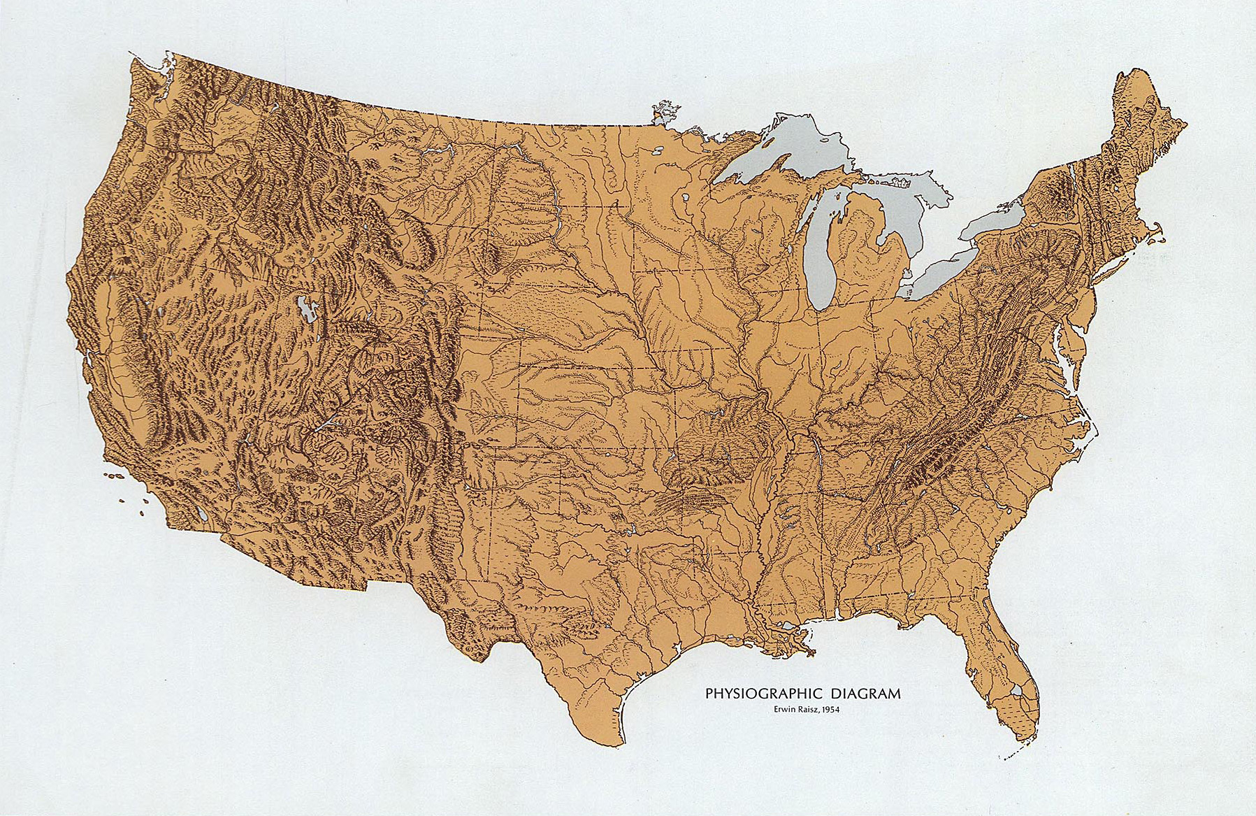
Again: be sure you can locate the great colonial cities on this map: New York, Boston, Philadelphia, Baltimore, Charleston, New Orleans, Quebec City, Montreal. Notice that all of these cities have good harbors and are located at or near tidwater—they are situated where they are because of the vital interface they offered for trans-Atlantic ocean transportation.
This is why one of the early actions of the U.S. government was to survey one of the nation's greatest harbors on the eastern seaboard:: Ferdinand Rudolf Hassler's New York Harbor Chart of 1845 for the United States Coast Survey, which if you're interested you can view and download from the Library of Congress website:
https://www.loc.gov/item/2004629241/
Now we move to a map of all the navigable rivers in the world. Here's a map of all the waterways—navigable or not—in the U.S.:
http://www.somebits.com/rivers/rivers-d3leaflet.html#7/44.438/-89.929
Be sure to zoom in and out of this map to see its full level of detail.
Now try zooming in to this map of waterways in the United States:
http://www.somebits.com/rivers/rivers-d3leaflet.html#13/43.5288/-89.4453
and compare it with the satellite view of the same area in Google Maps:
https://www.google.com/maps/@43.5477988,-89.4603681,9409m/data=!3m1!1e3
The landscape here in the vicinity of Portage, Wisconsin, is an excellent example of a palimpsest. Notice that here you have the two rivers (with their implied connections to the Mississippi and the St. Lawrence, the Gulf of Mexico and the North Atlantic); the portage between them; but also roads, railroads, Interstate highways, and the local airport, myriad corridors of human movement. This small local palimpsest reminds us that we need to consider more far more than just harbors if we're to understand the role of transportation in the making of the American landscape.
Let's turn to rivers next. How do rivers interact with other forms of human transit? In order to answer that question, we need to tell a story of water travel and land travel braiding together, from the 18th century to the middle of the 19th century.
III. Waterways and Roadways
The development of roads was accelerated by the investment first by colonial governments and then by the nascent United States in routes for delivering mail up and down the eastern seaboard. (Don't ever forget the importance of government capital, infrastructure, and services in promoting private sector growth in the United States; government investment in public and private infrastructure has played crucial roles throughout American history.) Even before the Revolution, the ability of mail to move seditious materials that were regarded as treasonous by the English Crown —pamphlets, newspapers—played an important role in fanning the flames of revolutionary discontent in the American colonies.
Note that roads didn't replace waterways; the two supported each other. Water is almost invariably the cheapest form of transportation, especially when speed doesn't matter, since ships and boats can move enormous weights and volumes of goods almost frictionlessly over long distances.
Especially important in the history of the American landscape is the Hudson River, which has played a role in the making of the American landscape quite out of proportion to its length or the volume of water it transports. Its main tributary is the Mohawk River, which is the only east/west river (other than the St. Lawrence, of course!) that crosses the Appalachian Mountains at a relatively level gradient. It is an extraordinarily important route. The depth of New York harbor and the linking of that harbor to the Mohawk River were among the most important reasons that New York City came to play the role it now does in the political economy of the North America--and, indeed, the world.
It was here that Robert Fulton's North River Steamboat (eventually renamed the Clermont) made its first run up the Hudson between New York City and Albany in 1807. The boat made its 150-mile voyage in what then felt like lightning-quick time: 32 hours.
The ease of crossing the Appalachians via the Mohawk corridor led to the suggestion as early as the 1780s that it might be possible to create a canal along that route linking the Hudson with the Great Lakes, thereby avoiding the obstacle represented by Niagara Falls for Great Lakes transportation (while also undermining Montreal's near monopoly over trade on the St. Lawrence watershed). The eventual result was the Erie Canal. Construction began in 1817, and the canal opened on October 26, 1825. It was an extraordinary engineering feat, constructed entirely by hand—largely by Irish laborers—and traversing a vertical elevation differential of about 565 feet via a series of 36 locks. There are good contemporary maps and further details about the canal at Wikipedia:
https://en.wikipedia.org/wiki/Erie_Canal
Recall that when the painter Karl Bodmer and Prince Maximillian zu Wied-Neuwied made their journey out to the Great Plains in 1832-33, Bodmer did a number of paintings of the areas of farms, towns, and lands newly opened to markets in Montreal, New York, and Europe beyond. Transport technology -- the Erie Canal and steamboats on western rivers -- made possible Bodmer's paintings of "first contact" and cultural encounter—and yet his depictions of native peoples rarely showed how much their world had already become integrated into a continent-wide transportation system.
In the 1820s and 1830s, there were more than a thousand miles of canals built in Ohio. Most of these were funded by government debts, but the canal-building bubble burst in the Panic of 1837. State and federal policies towards infrastructure development would nonetheless continue to play important roles in promoting the development of new transportation networks from this point on. With the appearance of these new canals in Ohio, the Mississippi River was now linked with the Great Lakes. This linking of the Great Lakes to other rivers was happening in other places, too: the Illinois & Michigan Canal, surveyed in 1824, opened in 1848. With the opening of that canal, Chicago and New Orleans were linked via water transportation without the prior need for portages along the route, though Chicago's transit linkages to New York would prove to be far more important economically, as you'll see when you read Nature's Metropolis.
The net result of this system was to funnel more and more of the goods of the continental interior into the great cities on the Eastern seaboard, making them great export centers for the Atlantic economy. All of this was made possible by a vast network of interior water routes, some constructed as canals and some naturally occurring as rivers (albeit with various forms of navigational improvements, many constructed by the U.S. Army Corps of Engineers). By the 1820s and 1830s, water routes also encouraged the migration of European peoples into these interior areas.
I've just read the landscape of water transportation. Now let's talk about land:
In 1775, Daniel Boone established the route of the Wilderness Road through the Cumberland Gap from North Carolina through Tennessee to Kentucky. 200,000 Euroamerican people would migrate via this route by the end of the 18th century. Technologies developed for these wagon roads proliferated, including the Conestoga wagon, originally developed in Pennsylvania, and the Prairie Schooner as a lighter version that became popular farther west. Along with these wagons came inns and saloons that developed along the emerging roads, providing lodgings for travelers and changing the landscape in the process. Builders also developed various technologies to improve the roads: cutting down logs and laying them crossways to create a what came to be called a "corduroy road." Macadam stone aggregate became ever more widely used in the middle decades of the nineteenth century, a paving technology invented by the Scotsman John McAdam in the 1820s.
Between 1811-1837, the Cumberland Road was rebuilt as the National Road. It was the first major improved road built by the U.S. federal government, running 620 miles from the Cumberland, Maryland (limit of navigation on the Potomac River, not to be confused with Cumberland Gap in Tennessee) to St. Louis. Notice that this period also saw the massive development of roads stretching farther into the U.S. West. And notice that the proliferation of these improved roads meant that information could flow more quickly, too: mail (and therefore news) that might once have taken weeks to reach areas distant from eastern cities now took just a few days.
Now: how did these two systems -- water transit and road transit -- interact?
Recall that the reasons John Wesley Powell's Colorado River Expedition became so celebrated was because the upper Colorado hadn't been navigated by a Euroamerican before his May 24-August 30, 1869 trip. But notice, too, this paradox of Powell's celebrated wilderness journey: he was only able to get his wooden boats to his launching place on the Green River because the Union Pacific railroad had been completed on May 10, just two weeks before he departed.
Just a reminder: I've said that these transport technologies support each other. In many instances, we remember these places as romantic examples of untrammeled taming of wilderness. But think about all the infrastructure required to make possible this movement of goods and people. Consider the example of the Pony Express: this short-lived icon of the American West (which operated only from 1860-61) was quickly replaced by telegraph lines, which changed the geography of information flow. But in the trans-Missouri West, even railroads only ran to a handful of places—so there was actually a very substantial increase in demand for horses and oxen in the West for decades after the completion of the transcontinental railroads. So again: don't imagine that new transportation technologies automatically replaces older technologies. More often than not, they're simultaneous and even mutually supporting, each carrying traffic of the kinds for which they're best suited.
How about the intersection of these two systems, waterways and roadways? The construction and operation of ferries was one way that the road and the river systems interacted. This explains the location of places like Harper's Ferry, the site of John Brown's famed 1859 seizing of a federal arsenal to protest slavery by trying to promote an armed uprising of enslaved peoples. In an earlier era, rivers had been the main corridors of movement across the landscape, but with the proliferation of roads, rivers began increasingly to feel like obstacles to be overcome. Ferries were often the earliest ways to do this.
Later, especially on larger rivers where ferry transit was less reliable and more dangerous, travelers began to look to bridges as preferred alternatives. On large rivers, these were among the most ambitious engineering efforts of the day. One of the greatest of all such projects was James B. Eads's bridge in St. Louis, opened in 1874. Driving pylons down into the river to support the bridge was an extraordinarily daring (and dangerous) feat of engineering and labor: so deep were the support structures that workers experienced the first known medical examples of "the bends." Even more famous was John Augustus Roebling's Brooklyn Bridge in 1883, one of the oldest cable-stayed suspension bridges in the U.S., linking Brooklyn and Manhattan for the first time. Bridges are among the great civil engineering features to change landscapes, connecting areas otherwise separated by waterways.
IV. Railroads
Bridges also enabled the proliferation of railroads. Let's look at some maps of railroads in operation in 1850. Paullin's transportation maps at http://dsl.richmond.edu/historicalatlas/ show the relative difference in density of rail transport in the U.S. North vs. the U.S. South, what would become the Confederacy. That difference is often noted in explaining important aspects of the course of the Civil War.
With the emergence of railroads came the emergence of corporations: corporate accounting, corporate management, and corporate capital financing were pioneered by these railroad companies. One example can be seen in the figure of Cornelius Vanderbilt (1794-1877), who amassed his immense fortune as one of the wealthiest men of the nineteenth century first by running a line of steamships and then as head of the New York Central and Hudson River Railroad, one of the first large corporations in the country.
Among the great government investments of the mid-19th century was the building of transcontinental railroads, which not accidentally came to a head just as the Civil War was looming. The question of whether California would join the nation as a free state or slave state made leaders in both the North and South desire to have that western area linked by rail to their part of the country. The federal government financed a series of Pacific Railroad Surveys—surveying alternative transcontinental routes—in 1853-1855. Then, a few years later, with the secession of the southern states in 1861, Congress was newly able to pass a number of landmark acts in 1862: the Morrill Act of 1862 (establishing land-grant universities like the University of Wisconsin); the Homestead Act of 1862 (giving 160 acres of "free land" to homesteaders); and the Pacific Railroad Act of 1862 (providing a land grant for the first transcontinental railroad), all of which had been blocked by southern senators until the start of the war.
The first transcontinental was built by two corporations: the Central Pacific, which built east from Sacramento (with San Francisco its implied western terminus); and the Union Pacific, which built east from Omaha (with Chicago and New York its implicit eastern termini). The capital costs of the Central Pacific rail construction (building from California towards the east) were much, much greater than those of the Union Pacific (building towards the west from Omaha) because of the challenging granitic mountainous landscapes of the Sierra Nevada through which Central Pacific was forced to build its route.
Compensation via federal land grants meant that capital for each company was tied to the number of miles the company built (at least in theory, they were supposed to gain investment capital by selling off land for each mile they constructed). As the Union Pacific approached the Rocky Mountains, they continued to bring goods out from Omaha, and they were able to sell at least some tickets as they passed through populated areas. The two lines finally met at Promontory Point (or Promontory Summit) in Utah on May 10, 1869. Leland Stanford of the Central Pacific drove the final Golden Spike connecting the two lines. The spike was connected to telegraph lines reaching back to the coasts, so the news was shared with great celebration on both coasts. Now the U.S. East and West were connected physically and informationally via the railroad and telegraph.
As we move foward in time to 1880, we start to see more transcontinental lines. By 1890 we have at least five lines crossing the West in the U.S. and Canada.
V. Roads Become Car Country
You've been reading about the impact of automobiles and highways on the American landscape in Christopher Wells's book Car Country, so I'll only speak briefly about it here by sketching how the geography of transportation I've been narrating throughout this lecture—harbors, waterways, roads, rail—was supplemented by automobiles. By 1920, a much larger set of "improved roads" (i.e. paved of some sort) stretched across the U.S. This vast expansion was in part made possible by the 1916 Federal Aid Road Act, establishing that the U.S. federal government would share the costs of road improvements with the states on a 50/50 basis. The scale of federal support was increased even more dramatically with the 1956 Federal Aid Highway Act (also known as the National interstate and Defense Highways Act), under which the federal government and the states contributed to the construction of Interstate highways on a 90/10 basis.
We've mainly traced a continent-wide story of changing transportation networks today, but the same things were happening fractally at the same time in cities and towns. Take New York as an example: the accretion of different transit types created a hugely complicated problem of how to manage the movement of people from homes to workplaces (to say nothing of shops and schools and recreational areas) on a daily basis. Especially given the complex geography of islands and waterways that characterizes the lands around New York Harbor, we see the proliferation of harbors, docks, wharves, ferries, streets, bridges, horse carriages, taxis, motorcars, trains, cable cars, trolleys, elevated railroads, subways, all of which weave together to create the extraordinarily complex transportation infrastructure that the New York Metropolitan Area relies on today. We'll return to that story later in the class.
VI. Air Travel
Wilbur & Orville Wright's first airplane flight was at Kitty Hawk on the Outer Banks of North Carolina (not too far from where Sir Walter Raleigh's Lost Colony was established on Roanoke in 1585), but the emergence of commercial aviation waited until the 1920s and 1930s. Once again, government mail contracts helped underwrite commercial air travel with a steady source of income, making the emergence of a coast-to-coast system of airports and routes financially feasible. As planes (and their fuel tanks) increased in size, the distances they were able to travel between stops grew larger, until regular non-stop coast-to-coast flights became possible following World War II. Airports emerged as vital growth centers for the metropolitan economy in the second half of the twentieth century.
Today we'll end where we began: thinking about the shifting and elaborating networks of transportation reflect on Erwin Raisz's map ... and thinking about the annihilation of space by time.